How Telecom Analysts are Leveraging Geospatial Enterprise Solutions
Download HEAVY.AI Free, a full-featured version available for use at no cost.
GET FREE LICENSEMassive profits and valuable information are hidden in geospatial and location intelligence for telecom industry experts and analysts. Telecom analysts can use spatiotemporal data to solve some of the industry's most significant challenges, such as network planning optimization and improving customer satisfaction. Modern geospatial enterprise solutions for telecoms ensure that analysts are equipped with the tools needed to gain actionable information and make educated, real-time decisions.
Read on to learn more about how analysts are using end-to-end geospatial solutions for telecoms to improve their performance.
Customer Service
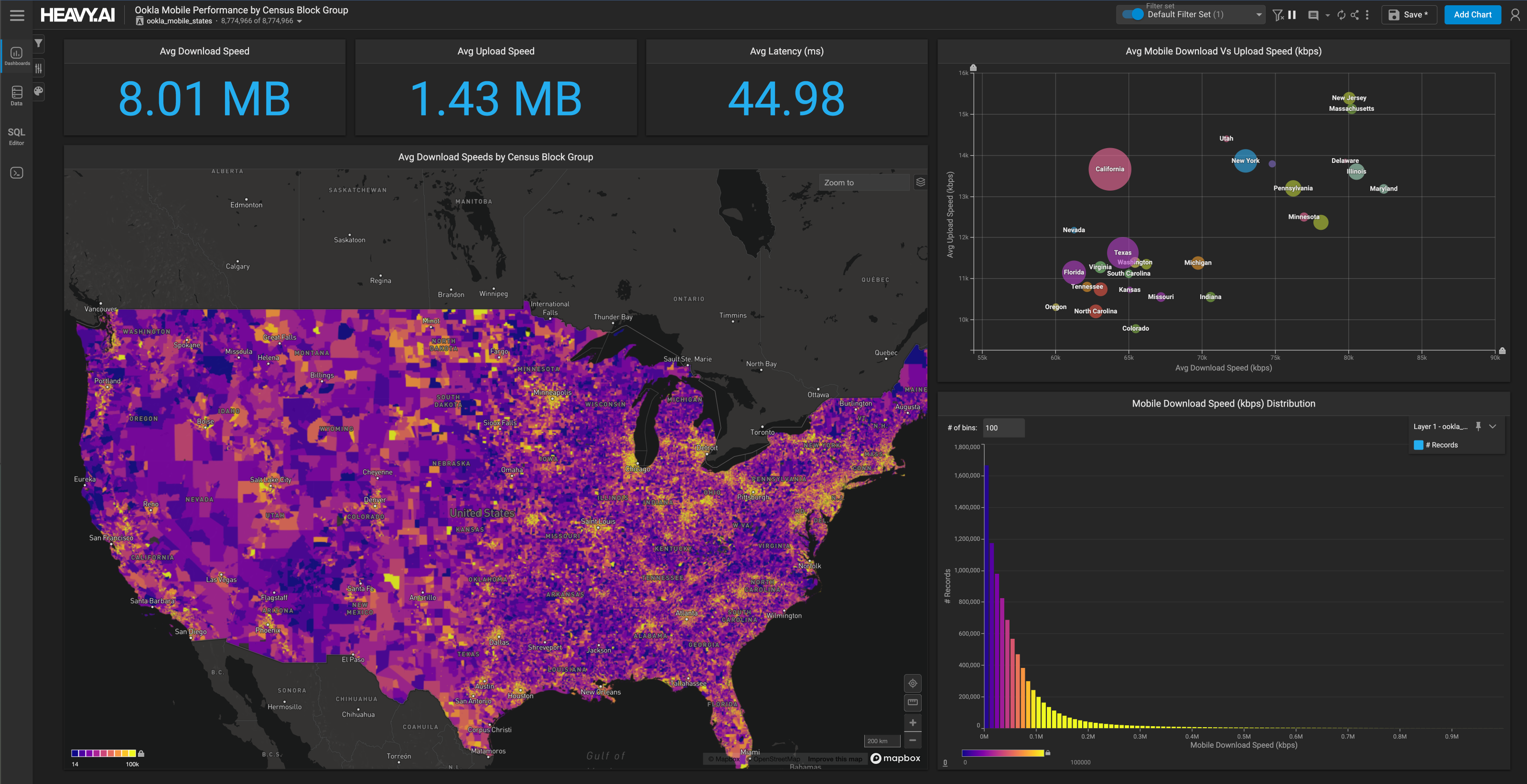
Geospatial software for telecoms provides carriers with geospatial analysis capabilities that drive location-based customer and network information. HEAVY.AI’s end-to-end geospatial solutions enable analysts to drill into any geographic area to analyze network performance and quality, and see who has the best network speeds and why so that they can improve network performance.
HEAVY.AI’s hardware-accelerated analytics, GeoSQL, and interactive visualization capabilities enable telecom analysts to proactively track changes in traffic flow across mobile networks in near real-time. Interactive querying, filtering, and visualizing multi-sourced geotemporal data makes it easy for sales and marketing teams to quickly and easily identify competitor coverage and the most profitable locations to build wireless services. Faster, more reliable service with competitive pricing improves customer satisfaction.
With HEAVY.AI geospatial capabilities, telecom analysts can visualize customer churn quickly and easily build an array of charts to identify patterns and correlations across disparate datasets or geographies. Telecom teams can use spatiotemporal data visualizations in combination with packet customer base experience scores to determine which towers are delivering the lowest quality experiences and pinpoint why.
Network Optimization
Telecommunication network data analysts and scientists can use end-to-end geospatial solutions to design and visualize network topologies in various use cases, including 5G network architecture optimization, which requires maximum speed, optimum capacity, and minimum interference. Spatiotemporal data visualizations enable telcos to deliver beam forming features, which are being deployed in 5G stations to boost signal strength and range in a particular direction, avoiding interference from trees and buildings.
By integrating geospatial data with a GPU-based rendering engine, data scientists and analysts can perform large-scale, interactive geospatial analytics at granular levels, querying and visualizing data in real-time. With access to GIS-based and spatiotemporal data at scale, data scientists can help telco experts solve the core optimization challenges: capital optimization, spectrum optimization, and performance optimization.
HEAVY.AI can rapidly visualize big spatiotemporal data and rapidly run complex calculations, empowering network operators and data scientists to place network assets efficiently, reduce interference between networks, monitor networks in real-time, derive real-time information from events, identify anomalies before they become problems, and maximize overall network operations. With robust spatiotemporal analysis, analysts can continuously map network performance by location and analyze how it changes in a specific service area over time.
Project Management
Geospatial enterprise solutions for telecoms offer a broad range of tools that help telecom operators stay organized and efficient. HEAVY.AI’s geospatial data platform helps analysts overcome big geospatial data's four main organizational challenges: delivery, transformation, collaboration, and visualizing and sharing information.
HEAVY.AI helps telecom analysts address the challenges of geospatial data analysis and improve project management with hardware acceleration. The HeavyDB SQL engine natively stores geographic and geometric data types. It can query this data in real-time and render it interactively. Heavy Immerse powers standard and complex data visualizations rendered in maps and charts.
HEAVY.AI’s visualization system and intuitive, immersive dashboards help streamline operations and make it easy for telecom teams to share charts and geospatial calculations with others quickly. Server-side technologies enable analysts to visually display dozens of distinct datasets in the same dashboard without joining underlying tables.
Final Thoughts
Geospatial data is undoubtedly helping to solve many of the most pressing questions facing telecom analysts today. Major industry players use the GPU-accelerated solution from HEAVY.AI to uncover critical business information that improves operations, identify new geospatial-enabled business opportunities, and efficiently explore big data. Adopting the latest geospatial enterprise solutions for telecoms is key to leveraging the power of location and delivering an unparalleled customer experience.